Sunday, November 13, 2011
Friday, November 4, 2011
Monday, October 17, 2011
Friday, September 9, 2011
Tuesday, September 6, 2011
Monday, September 5, 2011
Wednesday, August 31, 2011
Thursday, August 25, 2011
Sunday, August 21, 2011
Sunday, August 14, 2011
Monday, August 8, 2011
Tuesday, June 14, 2011
Tuesday, May 31, 2011
Monday, May 23, 2011
Tuesday, May 10, 2011


Mt. Talinis Adventure

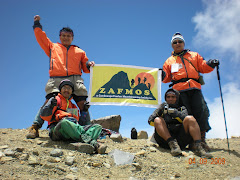
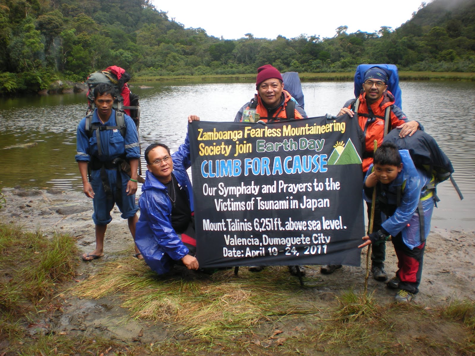
 Four members of ZAFMOS, to include the youngest, John Paul Tuazon made it to Mt. Talinis for its annual climb last Holy Week.
Thanks to the help of experienced guides in the area, trained by the Cuernos de Negros Mountaineering Group.
We found the climb challenging especially for some members, who got sick during the climb. Nevertheless, we did reach the top of the mountains and enjoyed the lake. in the area.
Mt. Talinis, which is in Dumaguete, is one of the most pristine and well preserved mountains we have ever climbed. Although not as high as Kanlaon, or Dulang Dulang and Kitanglad in Mindanao, it has its fair share of challenges especially of aging mountaineers like us.
We enjoyed it. and we looke forward to climbing it again.


Wednesday, March 30, 2011
Friday, March 25, 2011
Tuesday, March 22, 2011
Sunday, March 6, 2011
JOURNEY TO MOUNT MATUTUM
JOURNEY TO MOUNT MATUTUM
Municipality of Tupi, South Cotabato
What started as a joke relating Mt. Matutum’s peak to a nipple turned into one of our longest journey in our pursuit to climb the country’s highest peaks.As if South Cotabato’s majestic peak was beckoning and challenging us to conquer its 7,521 foot high peak, Mt. Matutum turned out to be our choice among the many peaks that we were planning to climb last Holy Week 2010..Indeed if one have actually seen its pointed peak protruding way above the clouds, it seems almost impossible to scale its summit given the extremely steep slope surrounding it.
So in the wee hours of March 28, 2010, our longest journey started with only the three of us in our 2003 model Lancer car which was fully loaded with coca-colas and energy drinks to perk up the senses of whoever was at the wheel. It was indeed a very long trip starting from Zamboanga City to Pagadian City, Iligan and Cagayan where we stayed overnight before proceeding to Davao via Bukidnon. The next day we continued our trip across the lofty mountain ranges of Bukidnon passing at countless breathtaking views from an altitude of about 4,000 ft ASL .Cruising above the mountains thru endless highways was the best moment of our journey as we enjoyed the chilly air outside and fresh mountain breeze,
Guided only by a Mindanao-wide road map and a GPS system, we drove on stopping only for lunch and occasional viewing of marvelous landscapes that came our way. On several occasions our GPS system failed to register our correct location due to the lack of signals and depended solely on the available road map causing us to lose ourselves by taking the wrong way. But three heads were better than one because after every extensive argument we were always able to find our way back to the right track. Anyway it was all part of the fun and adventure. After all it was supposed to be a journey, a total of over 2,000 kilometers from beginning to end.
At last after 2 days of travel we finally reached our destination, Gen. Santos City. Finding our hotel even right in the city proper took us quite sometime as none of us was familiar with the city streets. Again our GPS and city map did the trick. We checked in at Discovery Hotel at about 7pm on that day and after an hour’s rest, we took our much needed hot shower to sooth our aching body muscles. before taking a very sumptuous dinner of Gen Santos’s specialty, Grilled Tuna Belly, Yummy! Thanks to our very generous host for the day, Nap, as we call him and the owner of the venue, the Red Tent.
It was indeed a very memorable evening just before our climb the next day. After a few bottles of beers back at our hotel room, we called it a day and dozed off ,very much excited for the next day’s adventure.
After taking our early breakfast of protein-rich menu, we made our final check-list
of our gears and foodstuffs enough to last for about 5 days. So when we finally got all our stuff ready, we left our hotel and proceeded to Nap’s place where we left our car for safekeeping after which we were generously offered a most comfortable ride in Nap’s Ford Everest all the way to the Municipal Hall of Tupi for our climb registration and Permit. Along the way we caught glimpses of the very foggy peak of Mt. Matutum , silently marveling at its loftiness and beauty! The same question raced in our minds, Can we make it all the way to its very steep slope? Well that remains to be seen. Little did we know that it was one of the most difficult mountain our group have ever climbed.
Armed with our Climbing Permit, we proceeded to the designated jump-off area at Sitio Glandang about 7.5 kms away from the highway and passing thru fields of pineapple plantation as far as our naked eyes can see. We each rode on a Habal-Habal with our heavy backpack on our backs across the bumpy ride at break-necking speed! Upon arrival at the site we handed our Climbing Permit to the barangay head where we met our guide and porter to whom we entrusted our dear lives for the next 3 days. The jump-off site itself has already an elevation of about 3,000 ft Above Sea Level meaning we have still to laboriously trek on foot the remaining 4,500 ft all the way up to its very steep slopes. Mind you, the entire 2 days trek nearly took our breath away due to its steepness and sudden ascent unmindful of the acclimatization process every 1,000 ft as we were so eager to conquer this majestic volcano. It was here that we experienced scarcity of potable water supply so we had to strictly ration our consumption lest we will have no more water left upon reaching the peak. We spent the 1st night at Phase 1 campsite and already felt the bitter coldness even during the early hours of evening and much more at dawn. Waking up early donned in our thermal gears we scrambled outside to set up our camping stoves for our much needed hot coffee drink as it was so chilly outside our tents. Thick fog have almost entirely engulfed our campsite creating an eerie atmosphere around us.
After packing up our gears, we braced ourselves for what they termed as the final assault all the way to the summit at a punishing 70-80 degree slope for about 5 hours! It was at this point that we really experienced a very exhausting climb grabbing at every tree roots along the trail for support as we inched our way slowly to the top. It was a continuously vertical ascent with hardly a level portion and resting along the way means tightly hugging an oversized branch or an embraceable tree trunk for support at an angle too perilous for comfort. The looming peak was already noticeable as the treetops came into view .Then all of a sudden, the upward trail ended and BEHOLD , we were actually standing on the volcano’s very summit, a small flat area surrounded by steel perimeters to prevent climbers from dangerously getting too close to the very edges of the peak. This is it? We all silently asked ourselves and almost simultaneously, we shouted ‘WE MADE IT !”… The date..March 30,2010 So that’s it folks… Looking down the earth from a 7,521 foot high volcanic peak was our only rewarding moment for all the hassles that we had after that long journey from HOME, this is our story … our Journey to Mount Matutum…
T H E E N D
Joseph A. Nanquil –VP
Zamboanga Fearless Mountaineering Society ( ZAFMOS)